Antique Map Ohio Railway & County Platt Map 1909 Large Foldout


$100.00
Quantity available: 1
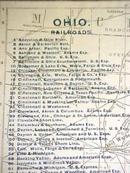
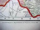
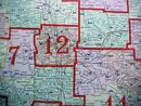
Offering this 1909 large fold out map of Ohio Railways and County Platt Map, copyrighted, published and printed by Rand McNally 1909. Measures 21" tall x 27" wide, very colorful and detailed. Good++ condition, no stains or tears. Great piece of history for your railway, train or map collection - nice map to frame and enjoy!
Great Expectations Antiques
Caldwell, Ohio
Dealer accepts: Cash, Money Order, PayPal, Check
Shipping: $6.50

