Antique Map US Postal Rates 1912 Large Foldout


$32.00
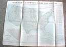
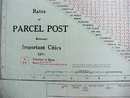
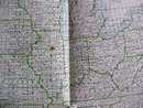
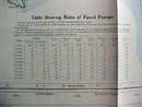
Offering this large 1912 Rand McNally United States Postal Service parcel post rate map of the United States. On one side is a map of the US states showing a four digit number code for each city. There is also a quick lookup chart for large cities and a chart of cost per pound for each zone - example 1 pound package varies from $.01 (cents)to zone 1 to $.05 (cents) to zone 8. How times have changed! On the other side is a listing per state of cities with the corresponding four digit number. Also information on postal regulations, restrictions, and other interesting reading. Measures 33 1/2 x 26 inches. Good+ condition, no tears or holes. There are two small brown spots - one on Illinois and one of Idaho. A great map for your postal paper collection!


