Antique Map Puerto Rico British Columbia 1901


$24.00
Quantity available: 1
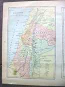
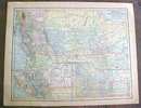
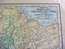
Offering this nice old map of the island of Puerto (Porto) Rico and the country of Palestine on one side and the Canadian providences of British Columbia and Manitoba on the other. This map was published / printed by The Crowell & Kirkpatrick Co, Springfield, Ohio, 1901 - this date showed only on the title page, copyright date of 1895 on the Porto Rico side and 1897 on the British Columbia side; this is an authentic map from 1901 - not a reproduction. Measures 13 1/2 inches tall x 10 1/2 inches wide, good++ condition, no holes or tears, light age toning, one small spot the is a little darker on the Palestine side and in the upper corner on the British Columbia side, does not really detract. Nice colors and details. These old maps look really great matted & framed. A handsome piece of history for your home or office!
Great Expectations Antiques
Caldwell, Ohio
Dealer accepts: No preferred Payment Option
Shipping: $7.50

