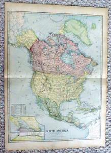
Antique Map of North America 1899


$28.00
Quantity available: 1
Offering this map of North America, dated 1899, by J. Martin Miller, Chicago Illinois. Measures 22 1/4" tall x 16 1/4" wide, good condition, no stains, one tiny 1/4" tear on top margin, has been mended on backside with archival tape, would not be noticeable when framed, since this is a large map there is a center fold line but is all one piece, not two. Nice colors, these old maps look really great matted & framed, this one still lists Canada as The Dominion of Canada. A handsome piece of history for your home or office!
Great Expectations Antiques
Caldwell, Ohio
Dealer accepts: PayPal, Cash, Money Order, Check
Shipping: $5.60


