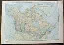
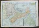
Antique Map Canada & Maritime Provinces 1910


$14.00
Quantity available: 1
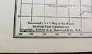
Offering this 1910 C S Hammond map of Canada on one side and Maritime Provinces (Newfoundland in the lower right corner) on the other side. This map was printed by C S Hammond & Co, New York, 1910 - it actually was part of Hammonds Handy Atlas of the World, dated 1910. This map is not actually dated 1909 copyright on it, but other map from this atlas are. (see photo).. Measures 8" x 5 3/4" (actual map size is 5" X 7"), good condition++, no holes stains, or tears, two minor creased in the margin corner, and one very tiny stain in the lower right corner of the Canada map side. These maps look really nice framed, perfect desk top or wall size for your home or office, a wonderful gift!
Great Expectations Antiques
Caldwell, Ohio
Dealer accepts: Cash, Money Order, PayPal, Check
Shipping: $5.60


