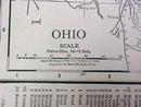
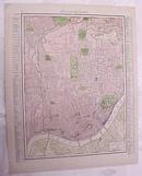
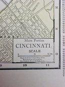
Map Ohio Cincinnati Streets 1917 Rand McNally


$24.00
Quantity available: 1
Offering this nice old 1917 map of the state of Ohio on one side and the main portion of Cincinnati Ohio streets on the other side. This map was published / printed by Rand McNally & Co, 1917. There is no date on the individual map, but it was acquired from the Rand McNally Atlas, published 1917 - this is not a reproduction. Measures 14 x 11 1/2 inches, good+ condition, no holes, tears, or stains( one tiny very faint mark near Cincinnati on Ohio side, does not detract, light age toning which adds to its charm. Nice colors and details. These old maps look really great matted & framed. A handsome piece of history and unusual art piece for your home or office!
Great Expectations Antiques
Caldwell, Ohio
Dealer accepts: Check, PayPal, Cash, Money Order
Shipping: $5.60


