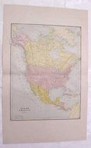
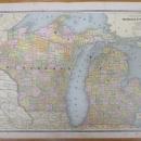
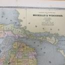
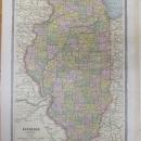
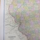
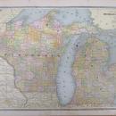
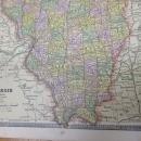
Map Michigan Wisconsin Large Fold Out Crams 1883 Illinois


$40.00
Offering this wonderful old 1883 Crams large fold out map of Michigan and Wisconsin on one side and a smaller map of Illinois on the opposite side. On the reverse side of the fold out side is a smaller map of Illinois, and on the other side is engravings of US state seals. There is a total of 38 state seals, each is about 1.5" square.This map was engraved by George F Cram copyright in 1883, and printed by Henry S Stebbins, Chicago. These individual maps do not have the date on them but were part of Cram's Unrivaled Family Atlas, dated 1883, these maps are not reproductions but are authentic copyright 1883. The size of the actual large fold out measures 18.75 inches x 12.2 inches from printed border frame to border frame, has center fold. The Illinois map is 12.2 x 9.0" with no fold line. Good++ condition, on the Illinois map, no holes or tears or stains. The Michigan/Wisconsin map has some minor staining in the white border only, slightly puckered paper at the center fold near the edges only, the one pucker line goes about .80" into the map on the edge of Lake Michigan. Only noticed under close inspection. Very nicely detailed, excellent colors; mat and frame this handsome piece of history for your home or office or an antique gift!