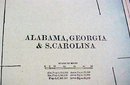
Map Alabama Georgia South Carolina 1894 Lg Foldout


$55.00
Quantity available: 1
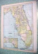
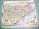
Offering this handsome colored 1894 large foldout map of the states of Alabama, Georgia, and South Carolina - on the backside are maps of the states of Florida and North Carolina. This map was published / printed by The C.A.Gaskell Family & Business, Atlas of the World; John F Waite, Chicago, IL 1894. No date is printed directly on the map but it was acquired from the C.A. Gaskell Atlas, published 1894 - this is not a reproduction. Measures 13 1/2 x 22 inches, good+++ condition, no holes, tears, or stains; light age toning that adds to its charm. Nice colors and details. These old maps look really great matted & framed. A handsome piece of history and unusual art piece for your home or office! Shipping/insurance to any continental US address will be $6.00
Great Expectations Antiques
Caldwell, Ohio
Dealer accepts: Money Order, PayPal, Check, Cash
Shipping: $6.00

