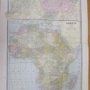
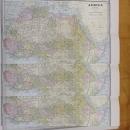
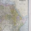
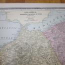
Map Africa Large Fold Out Crams 1883 South Africa


$45.00
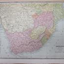
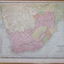
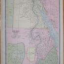
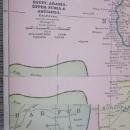
Offering this wonderful old 1883 Crams large fold out map of Africa on one side and a smaller map of the South Africa on the opposite side, and on the remaining reverse side of the fold out is a smaller map of North Africa. This map was engraved by George F Cram copyright in 1883, and printed by Henry S Stebbins, Chicago. These individual maps do not have the date on them but were part of Cram's Unrivaled Family Atlas, dated 1883, these maps are not reproductions but are authentic, copyright 1883. The size of the actual large fold out measures 20 inches x 11.5 inches from printed border frame to border frame, has center fold and included in this measure is the top map of Marrocco, Algeria & Tunis. The North and South Africa maps are 12.4 x 9.6" with no fold line. Good++ condition, on all 3 maps, with no holes or tears or stains, some very minor age toning out on the white borders in the margin areas, seen only under close inspection. Very nicely detailed, excellent colors; mat and frame this handsome piece of history for your home or office or an antique gift!


