Antique Map Nova Scotia PEI Quebec 1916 Rand McNally


$28.00
Quantity available: 1
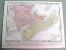
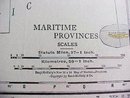
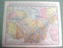
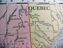
Offering this handsome colored 1916 map of the Maritime Provinces of Nova Scotia, New Brunswick, and Price Edward Island on one side and Quebec on the other side. This map was published / printed by Rand McNally & Co, 1916. No date is printed directly on the map but it was acquired from the Rand McNally Atlas, published 1916 - this is not a reproduction. Measures 14 x 11 inches, good+++ condition, no holes, tears, or stains; light age toning that adds to its charm. Nice colors and details. These old maps look really great matted & framed. A handsome piece of history and unusual art piece for your home or office! Shipping/insurance to any continental US address will be $6.00
Great Expectations Antiques
Caldwell, Ohio
Dealer accepts: Money Order, Cash, PayPal, Check
Shipping: $6.00


