Antique Map New York/Michigan 1902 Large Crowell


$32.00
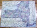
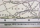
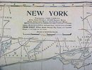
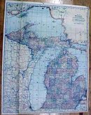
Offering this nice large foldout antique map of New York state on one side and Michigan on the other. This map comes from the Peerless Twentieth Century Pictorial Gazetteer. Note the attractive colors, and clear markings! This map was published / printed by Crowell Publishing Co, New York, 1902, however this map has a copyright date of 1898, by the Matthews-Northrup Co. marked on one side - not a reproduction. The map measures 21 1/2 inches tall x 16 inches wide, very good condition, no holes a few minor edge tears, some slight foxing around the outer edges. Even with the fold lines, these maps look great after framing/matting work is complete, which makes the majority of the fold line disappear. This particular map is one of two larger maps from the mentioned atlas, and is slightly thinner paper than the other smaller maps, yet less foxing noted than the others, and also has more fold lines than most foldout maps. Wonderful colors and details. These old maps are excellent for framing. A handsome piece of history for decorating your home or office!


