Antique Map Kentucky Maryland Delaware WV TN Crams 1883


$35.00
Quantity available: 1
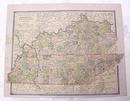
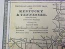
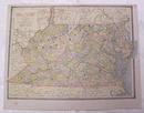
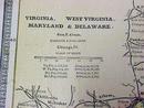
Offering this wonderful old 1883 Crams map of Kentucky & Tennessee on one side and West Virginia, Virginia, Maryland, and Delaware on the other side. This map was engraved by George F Cram and printed by Henry S Stebbins, Chicago, 1883. These individual maps do not have the date on them but were part of Cram's Unrivaled Family Atlas, dated 1883, these maps are not reproductions but are authentic printed 1883. Measures 13 1/2 inches x 11 1/4 inches including blank margins. Good condition, no holes or tears; small stains on blank margin on both sides which would not show when framed. Very nicely detailed, excellent colors; mat and frame this handsome piece of history for your home or office or an antique gift!
Great Expectations Antiques
Caldwell, Ohio
Dealer accepts: Money Order, Check, Cash, PayPal
Shipping: $7.80

