Antique Map Illinois & City of Chicago 1901 Colorful


$20.00
Quantity available: 1
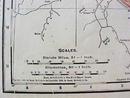
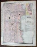
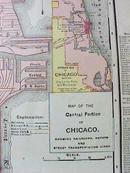
Offering this nice old 1901 map of Illinois on one side and detailed street map of Chicago(including railroads, elevated railroads, cable lines, horse, cars & electric lines) on the other. This map was published / printed by Rand McNally & Co, 1901 - copyrighted 1895. Measures 13 1/2" tall x 11" wide, good+ condition, no holes or tears, nice aged tone of paper. Nice colors, these old maps look really great matted & framed. A handsome piece of history for your home or office!
Great Expectations Antiques
Caldwell, Ohio
Dealer accepts: Check, Cash, PayPal, Money Order
Shipping: $5.60


